INTRODUCTION:
The Rupin Pass trip, known for its high altitude hiking at 15250 feet, provides adventure seekers with pure adrenaline and pleasure. The magnificent walk travels across Uttarakhand and Himachal Pradesh, two of the “Lands of Gods,” from beginning to end. So it stands to reason that those who enjoy spending time in nature will find absolute happiness in the pristine splendour of the picturesque sceneries along this walk.
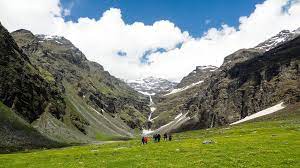
A trekker has the opportunity to pass through undeveloped villages, verdant pasturelands, suspension bridges, dense forests, breathtaking rivers, and gushing streams and waterfalls while on this journey.
OVERVIEW:
Pass through the two breathtaking mountain top villages of Jhanka and Mori in the Himalayas.Walking through the Govind National Park’s lush oak, pine, and rhododendron woods
Enjoy the unusual Himalayan flora and fauna’s exotic sights.Learn about the hill people’s culture and traditions.
Trekkers experience an adrenaline surge when they cross suspension and snow bridges, which increases the exhilaration.
When waterfalls are this high, they give the impression that the Almighty is pouring down holy water from the heavens.
Pray at the Pokhu Devta and Kinnaur Temple, which are located at the confluence of the rivers Rupin and Supin.Discover the captivating beauty of the snow-capped Alps and towering Kailash Peak.
Best Time to Visit Rupin Pass:
There are two seasons in which to complete the Rupin Pass trek: one during the summer, from May to June, and the other during the post-monsoon season, from September to October. Notably, considerable snowfall occurs in the summer, while the post-monsoon season brings greenery and clear skies. But as winter approaches, the grass begins to turn golden around the end of October. In Rupin Pass, the daily average temperature ranges from 13 to 18 °C while the overnight ranges from 0 to 7 °C.
An Overview of the Prolonged Journey to the “Land of Gods”: Rupin Pass
Region: Himachal Pradesh and Uttarakhand
Approximately 8 days.
Moderate to Difficult in terms of grade
52 km maximum distance at 15250 ft
The Rupin Pass trip is renowned for showing a dramatic contrast in the green and snow-covered landscapes, making it one of the most challenging and stunning paths. The route is praised for its stunning natural beauty and endearing charm. A stroll through the valley, which is home to stunning vegetation and fauna, is a singular experience in and of itself. This voyage is one of the most remarkable due to the panoramic view of the Kailash Peak and the River Tons.
Moving forward, the trail led them past some breathtaking vistas of hills, and it took them around 7 hours to travel from Mussoorie to Dhaula. Dhaula, which lies in the Uttarkashi district, served as their trek’s base camp. After two hours of relaxation at the base camp, our guide gave us a full explanation of the schedule and routes. Each trekker received a map of the eight-day journey from him as well.They spent the night in the camp after dinner.
The following morning, they awoke to a magnificent sunrise, and were all instructed to perform some stretching and warm-up exercises. Later started the challenging Rupin Pass trek from Dhaula to Seva. Rustic hamlets, fragrant apricot and apple orchards, and suspension bridges over the River Rupin were all along the trail. They discovered a small shop on the road that a Pahadi couple was operating selling tea and biscuits.
They couldn’t resist drinking hot tea with my snacks.After that, they walked through the jungle and grasslands for about 3 hours, taking a break every hour.
Meanwhile, the murmuring of the river fell upon my ears as a well-crafted melody. Upon reaching our destination, they stumbled upon an impressive temple known for its Kinnauri traditions. After a 10-minute hike, they reached the bridge that connects Uttarakhand and Himachal Pradesh. After crossing this suspension bridge, they arrived at Seva and set up camp along the river.
On the third day,
they entered a dense rhododendron forest, and after walking for about two hours, they crossed a wooden bridge called “No man’s Place.” Their guide said this is because the bridge is not owned by any state. First they reached Gothang, from there they proceeded to Kwal, and next arrived at Jixun in two hours. They are energy drinks and bars on our way straight. We stayed in Jiksun for about 20 minutes and took some nice camera shots of the valley and the snow capped mountains.After walking for about an hour we reached the village of Jaka.
The trek became more difficult as the trails to the main river tributaries became steeper and more difficult.The lush forests and beautiful snowfield scenery kept us motivated. We crossed a snow bridge leading to a rhododendron forest. Next, walk for about an hour to arrive at Salwas thatched campsite. We enjoyed the breathtaking view of Lupine Falls from here.
After breakfast the next day,
start trekking. We walked through scenic and dense maple and blue pine forests. After walking for about an hour, get off at the river and cross the bridge to the opposite bank. The forest consists of birches, rhododendrons and alpine meadows. Here, I was captivated by brightly colored wildflowers, including Himalayan daisies, lilies and blue poppies. Furthermore, after 6 hours we arrived at Danderas Thatch.
The next morning we all hiked through patches of snow to reach Upper Waterfall Camp. After a leisurely walk of about three hours, we arrived at our campsite where we spent the night.
The next morning we descended towards Sangla and the road became steeper as the elevation dropped. We kept a good pace and moved carefully. About 6 hours to Sangla.